
Buckskin Gulch
Campsite 15, May 5, 2023 - Three days ago, we hiked from Edmiaer’s Secret to Buckskin Gulch. When we reached the main trail, we had turned around, as we still had a three mile hike back to our Jeep. The plan was to return and enter the Gulch through Wire Pass, which is the main access point.
We placed our post-it note, with our parking permit confirmation number for today, on the dash and checked the weather on several websites. There was no rain predicted anywhere close to the area we were hiking.

A Few Clouds on the Western Horizon
The Flower Moon Setting
When we arrived at the parking lot for the Buckskin Gulch Trail and The Wave Trail it was about half full. We took that as a good sign, as other people were hiking today, but not so many that the trail would be crowded.
We parked and headed down the trail which was simply a wash. Around half a mile in, we encountered a group of hikers who had stopped to consult their map. They were looking for The Wave Trail and were concerned they had missed it. We assured them it was a very popular trail and they weren’t going to miss it. They just needed to look for the brown fiberglass trail markers with white lettering.

A Typical Trail Marker
We hiked on with them following close behind. Soon I spotted their sign to the south of the wash and pointed it out to them. While they turned to hike up hill, we continued in the wash. At one point we saw ratchet straps tossed to the side of the trail. They looked new. Strange, but not as strange as the wrecked cars supporting the highway that we had seen at Catstair Canyon. Eventually we entered an area of large rocks and came to what was clearly the opening to the slot canyon. Sitting to one side was a homemade cart. It had wheels from a garden cart, but the structure was made of rough cedar logs. Next to it, on the ground, was another strap like those we had seen earlier along the trail. The owner of the cart must have dropped the straps we had seen previously. Looking at the cart, then each other, we shrugged and entered the slot canyon. But this wasn’t just any slot canyon. This was Buckskin Gulch!
Buckskin is the longest continuous slot canyon at 13 miles long. The section we were hiking, which starts at Wire Pass, allows an easy out and back day hike. We could hike as far into the canyon as we wanted. We just needed to be out before dark as we didn’t have an overnight permit and hadn’t brought head lamps. With the proper permit, and gear, you can hike the entire length of the canyon plus part of the Paria River, a total of 44 miles.
The upper section of Buckskin, where we were hiking, is an easy hike so inexperienced hikers get their parking permit and hike without thinking about the dangers of hiking in a slot canyon. If you check the local weather forecast and it says clear skies, that doesn’t mean it’s OK to hike that day. Rain, many miles away, or as little as 1/4 inch can cause flash flooding in the canyon. The surrounding sandstone forms an impervious barrier to water infiltration. Instead of seeping into the ground, water flows into the gulch. You need to carefully check the weather and be aware of your surroundings. Even knowing the location of exit points might not be enough to save you since there aren’t many. Over the 44 mile length, there are five exits: the one we were entering by today, Wire Pass; the entrance we used a few days ago, Buckskin Gulch Trailhead; the Middle Route at 6.5 miles down canyon, which is rated as a difficult exit route; White House Trailhead, which requires hiking upstream in the Paria River which is a 21 mile hike; and the Lees Ferry exit, which requires downstream hiking in the Paria River and a special, hard to acquire, overnight permit, a total of 44 miles.
You might be thinking, climb out of the canyon and hike to the nearest road. That’s not practical. You’re hiking at the bottom of a canyon whose walls can range from straight up to overhanging. There are no handholds in many places and the canyon is deep. To climb the walls you would need rock climbing gear. “Up,” is clearly not a practical emergency escape route. Even if you could climb out, there are no roads for miles through rough terrain.
Just as important for safety as knowing where exits are, is knowing not to camp in the canyon. People die here. In March of this year, a flash flood caught 3 men camping in the gulch. Two died when they were swept 3 to 4 miles downstream while the third was found alive but needed to be hospitalized for hypothermia and injuries. It isn’t that the gulch is dangerous, it’s more doing stupid stuff can get you killed. “Don’t do stupid stuff,” is a good policy for life in general.

As we hiked, we met a woman with a large backpack. She was hiking alone on a one-way overnight trip. She had hired someone to drop off her car on the far end. I hoped she wasn’t planning to leave by the Middle Route. The ranger had told us it was under eight feet of water. But that was also the ranger who said he took his dog to Catstair Canyon.
There were only a few obstacles on our route, like this boulder that we had to climb over.

Just remember, if you have to come back the same way you go in, don’t climb down something that you can’t climb back up. Later in this post, you will see him climbing back up. The bottom of my bag rubbed against this boulder, but I’m standing on a pile of rocks. Thanks to whomever stacked them there!
A short distance later, we heard what sounded like a drill. That made no sense! As we hiked closer to the sound, we heard voices. Someone was building something here in the canyon? Then we saw what it was. A trail volunteer, and owner of the cart we had seen earlier, was building a ladder. Here is the ladder from on our way out. The level sand floor and lighting makes the entire area look fake, like a movie set.

We thanked the volunteer for the ladder. He said it was no problem as they didn’t, “like blood on the rocks.” He also said they replace the ladder as needed. I asked where the old ladder was. He said we would see it later. We soon did.

That’s the old ladder. Its height is a good indicator of how high the water got. Knowing that walls here are 4 to 5 feet apart allows you to estimate the water was about 25 feet deep. You can also see there is more wall above the ladder than below it. As we hiked, we found more debris. It was well above our head so we had no trouble hiking under it.

At one point I found a large moth in the middle of the trail. I had to take a photo so I could look it up back at camp.

White-Lined Sphinx (Hyles Lineata)
These moths are sometimes called hummingbird moths as they can hover like a hummingbird. They are about the same size too, with a wing span of 2-3 inches. It was cool to see one. Too bad it wouldn't be flying out of the canyon.
You would think this sort of place would be quiet. It is when your alone, but anyone approaching, who is talking, makes a lot of noise as their voice echos off the walls.
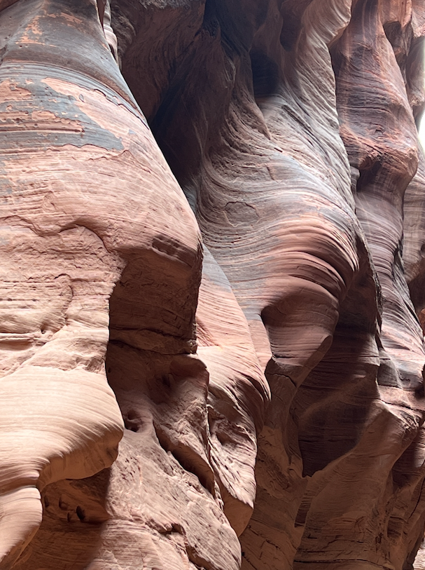
No amount of exploring these carved stone walls can reduce my curiosity for what shape is next. Imagine water rushing down the canyon, its flow matching the curves of the rock walls. The turbulence must be extraordinary. Then you imagine what it would sound like. You must be able to hear the crashing of the water throughout its entire length. But where would you go?

A little before noon we arrived at a wide spot in the canyon. It was at least 60 ft wide, probably wider. There was enough space here that the water could spread out, slow down, and deposit sand and rock. There was a 15 foot deep deposit of sand and gravel on the far side of the canyon with mature trees were growing out of it. That means the deposit had been here for at least as long as the trees had been growing. We stopped to climb to the top, look around, and have lunch. If there was going to be a good place to stop, this was it. We wouldn’t be blocking the path that was typically less than 8 feet wide. As we ate lunch, we watched other people wander by. Most didn’t notice us. Then I felt something hit me. And then again! We looked at each other. Rain! It was really more of a sprinkle. We could stay here, in a safe place, but if it did flood, we would be trapped until the water receded. Alternatively, we could get out while we could. We knew that it was probably a quick sprinkle and nothing to worry about. Still, we scrambled for our gear and headed back up the gulch at double time. Soon we were being followed by the overnight hiker we had seen near the beginning of the trail. She was getting out too. It was nice to know, if we were overreacting, someone else was too. She was traveling faster than we were, so we stepped to the side and let her pass. We continued to see hikers still heading down the canyon. They’re adults and can make their own decisions. Except, when I saw a guy hiking with a baby strapped to him, I had to ask if he was concerned about the rain. While I don’t remember his exact response, it was something like, “Why?” We didn’t explain, but said, “OK!” and continued our fast escape. Soon the rain stopped, but we were not going back in. It could have rained longer and harder upstream. Soon we were back at ladder and then the boulder.

It was sunny above the canyon, but we returned to camp and prepared to leave for town the next day. We had no idea it would be our last night out.
Back at home, reading the newspaper, we saw that a flash flood had killed two people in the gulch on May 23, 2023. Hiking here is deceptively easy.
***
For the, previously posted, final tale from this adventure click HERE.