
Climbing Blacktail
October 2, 2023 - We arrived at the trailhead around 9:30. It was a beautiful fall day. We were a group of four, planning to summit the mountain. But first we stopped by the Diamond Window Cabin. The cabin was built in the early 1900s by the PJ Gardner family who lived in the cabin until the 1950s.
After peaking in the one open window and reading about the family, we returned to our car to retrieve our day packs.

The trail, which began slightly higher than Stagecoach Reservoir, was now well worn by hunters. Luckily we were the only people in the area today. Taking the hike during rabbit and grouse season was a good plan.
The trail crossed the foot of the mountain through tall grass then began to climb a drainage. Soon the trail was passing to the west of a grove of aspens in full fall color.

As we admired the bright yellow of the aspens we came upon a large rubber tire. The tire must have been at least 7 foot in diameter. We wondered how someone got the tire up the slope and about its original use. In its current location, it marks an old well that has been capped with concrete. The next question is why is there a well here, far from the cabin, which has a small pond nearby. Then we noticed a path farther into the trees. Here we found a stone foundation for a larger structure. Interesting but not our objective.

Soon we moved on, climbing steadily past more aspen and cherries. We arrived at a small clearing where there was a pond that was dry. Our map indicated the trail split here but we didn’t find any fork, only the trail we wanted. We continued to climb, spotting bear droppings, filled with cherry pits, along the trail. It was obvious we were not alone. As we walked, we talked of events in our lives. Talking is a good way to let a bear know you’re there without having to call out specifically for the bear.
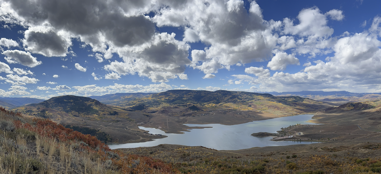
The trail continued to climb. I had to stop frequently to catch my breath. It gave us time to enjoy the view. We had started at closed to 7,380 ft and we’re planning to climb to 8,678, if we could.

West View, Toward the Flat Top Mountains
We knew there was private property near the top and we were concerned that our trail would cross it but we found a new fence that our trail followed until we came to a pond that was used by cattle.

Private Property

Cattle Pond
We didn’t pause here as the land was flat and we were in good spirits as we had been expecting bushwhacking before now.
Passing to the west of the pond, we continued our climb into a ponderosa grove.

Is there a Bear in There?
Around 1,000 ft past the pond, our trail stopped in light brush. From here, we bushwhacked a bit farther south. We were watching the trees above us looking for the the narrowest section of trees to begin our climb up.
Brush under the trees was dense and by going farther south we missed almost all of the dense growth. We knew where to turn from the satellite images we reviewed beforehand.
Now we were climbing through two-foot tall sagebrush and bitterbush. Everyone was picking the path that seemed the best to them. I came across the skeleton of an elk. It had been dead awhile. Its bleached bones were scattered around.

Elk Bones
I stopped for a photo then hurried to catch up with the group. The climb was very steep and I was glad to have bushes to hang on to in case I stumbled.
This was slow going but it was perfect for breathing purposes as I didn’t need to stop to catch my breath.

Not Quite the Top
Rounding the peak slightly to the south (right) while climbing, we came to what had appeared previously to be the top. We stopped to admire the view. We could see Steamboat Springs to our north, Stagecoach State Park to the south, and the Flat Top mountain range to the west. To the east there was more mountain to climb.
South View, of Stagecoach State Park

North View, Steamboats Springs in the Valley on the Right
At this elevation, 8,678 feet there was only rock and short ground cover. With easier hiking, we quickly reached the top where a wooden post supported by a cairn (a rock pile) marked the location. We were thrilled. The hike had not been as difficult as we had thought it would be. We took photos and grabbed snacks from our packs. The wind was picking up and we could see dark clouds headed our way. (See clouds in the photo above, West View, Fat Top Mountains.) We didn’t linger but picked up our packs to head down.
Down is easier as you aren’t fighting gravity; however, it’s harder to determine the correct direction to hike. We ventured farther into the trees than on the way up, but it was fine as my very handy husband had marked where we left the trail in his Gaia app. This made getting back to the trail a matter of pushing on through the brush.

Fall Color with Dense Brush
Soon we were back on the trail passing the pond, then the cattle fence, and finally the enormous tire. As we walked, we were mostly quiet which requiring us to occasionally call out, “Hey Bear” to ensure no unfortunate encounters.
We all agreed it was a good hike. We had covered about 4 miles in 3 hours while climbing around 1,300 feet.
It was good to having climbing partners. As we approached the car, someone mentioned that they wouldn’t mind walking along the bench at the top of the cliffs on the south side of the mountain.
As we drove home we discussed our next adventure which will be a car to car route along the top of the cliffs.

East View, Our Next Route
As we collapsed on the couch back at the house, we noticed rain just starting to hit the windows.
***