July 2024
The Start of the Dempster
This is the daily log for our Summer 2024 trip. I will be updating it daily during our trip so people can find us if they need to. (If we get lost or for family emergencies) It is written with the most recent day at the top for easy reading at the time. To read it in order you will need to start at the bottom (watch the dates)
To see the Map of our Adventure click HERE.
Camp ?? July 31, Klondike River 230 miles, 1201ft
Finished the Dempster yesterday. We will be crossing into Alaska today and making camp early. I plan to sort out the camp numbers and travel map.
Camp at 66.0? -137.?? “Origami Kitchen”
We will be finishing the Dempster highway today. We plant to wash our rig in Dawson City and camp on the YT side.
Camp 15, July 26, 183 miles, 79F, 2,318 ft

Today was a big day. Lots of great scenery, a fantastic campsite, we didn’t run out of gas or breakdown. We found a great camp just north of the arctic circle sign.
Plan for tomorrow. We haven’t decided. It’s pretty great here. We might leave; we might stay. I’ll let you know.
***
Camp 14, July 25, 0 miles, 3,260 ft
64.82, -138.31
We were awakened by the most ridiculous of sounds, a willow ptarmigan. To hear it click the link below and tap unmute in the upper right corner.
https://www.tiktok.com/@lesombie/video/7288426967043509547?lang=en
Camp 14, July 24, 54 miles, 86F, 3,260 ft
64.82, -138.31

We had a short travel day, but hiked a few trails.

Then we found a great camp by the Blackstone River. Yes that is an extinct volcano on the upper right of the photo. We plan to stay here tomorrow to explore the river and have a cleaning day.
Camp 13, July 23, 253 miles, 82F, 2,150 ft

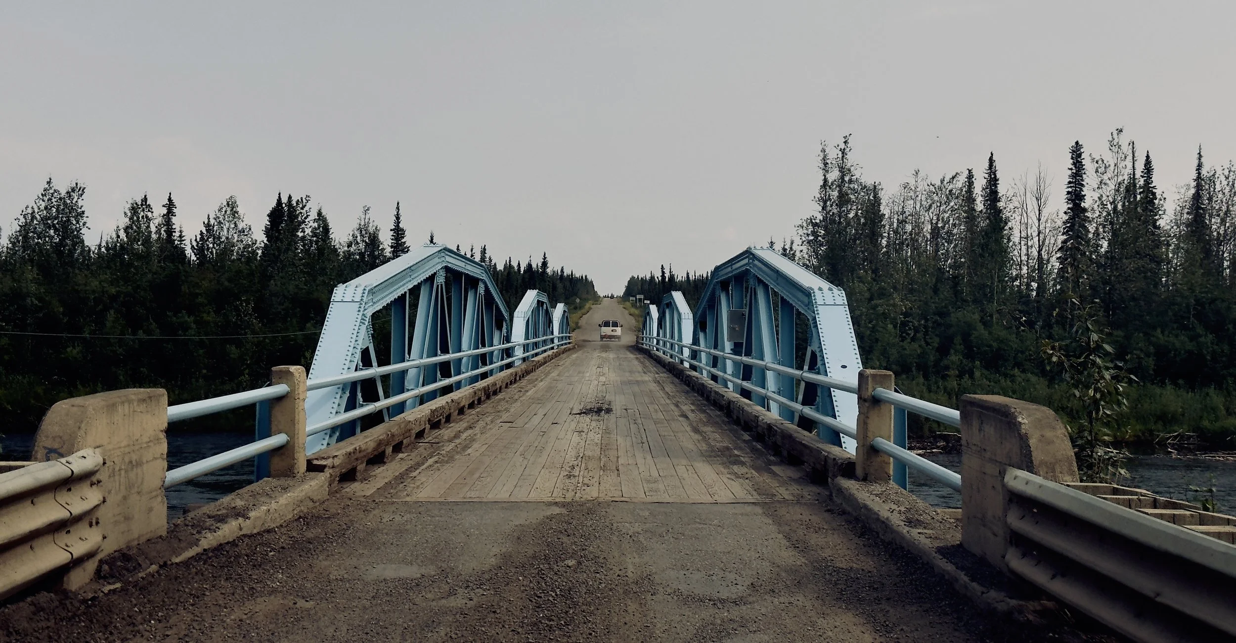
We turned onto the Dempster around 4:00 pm today. The road is in excellent condition so far. Obviously there are corrugations but we are aired down and proceeding at 30 mph.
We found a cozy spot for the night approximately 200 yards off the main road. It is down an overgrown trail, so we don’t expect company unless they don’t realize we are here.
Tomorrow’s plan. Pack up late so other people can move then look for a better spot we can stay at a few nights. We also intend to check out the campground. That is probably a, “NO!” We’ll see
There are a few hiking trails we want to check out. But would rather not have to drive too far. It is a gravel road and while I expect to need a new windshield by the time we get home, it is always nice to be optimistic.
***
Camp 11 Frenchmen Lake, July 22, 1978 ft
60.67, -129.23 (66.34 north is the arctic circle)

Yukon River
We decided to have a short day and air out the wet tent. It rained for about 15 hours yesterday. With only a couple of breaks for a few minutes each. We were glad to have a comfortable indoor space to sit.
We finally turned off from the Alaskan highway. There is much less traffic now.
While we are staying in a paid campground, there are only two other camper here. They are at the other end of the campground.
Tomorrow we should reach Dawson City.
***
Camp 10 Wet Skeeter Lake, July 21, 264 miles, 2,619 ft, 79F
59.36, -129.10 (66.34 north is the arctic circle)

We have been having problems connecting to the internet due to tree cover in paid campsites. We stopped today at a rest stop to set up the starlink so we could publish this week's post then continued traveling toward Whitehorse.
Around 5:00 we found a nice private wild campsite just north of Teslin, YT.
***
Camp 9 Boya Lake, July 20 - 212 miles, 78F, 2,340 ft

Around 2:00 we start looking for a campsite. But they hide every side road and you can’t slow down because there are vehicles behind you. After driving and driving. We came to Boya Lake, which we have been hearing about since we entered BC. So we stopped there. It was crowded.
When we woke up this Ruffled Grouse chick was having breakfast in the bushes by our camp. Its mom was hidden under some brush calling, teenagers trying to be independent!
***
Camp 8 - Cassiar Power, July 19, 72F

View of Camp
This was our first day on the Cassiar highway. While there are other vehicles on the road they are either tourist like us or work vehicles - road maintenance or mining. But each mile gets more remote and more beautiful.
The software update / outage that occurred today was only a problem for us in having to pay for gas old-school style (inside). The experience made it feel more remote. Perfect timing for us Crowd Source!
***
July 18 Lakelse Lake, 71F w/Rain!

We are staying at Lakelse Lake campground another day and driving to Prince Rupert to look around. We wanted to drive to the top Mount Hayes but there were low clouds, therefore no possibility of a view. The drive along the Skeena River was very nice. The mountains here rise from the edges of wide rivers. Its very nice and well worth the side trip.
Our camp neighbors are locals and gave us info on places to check out as well as camp. Thanks Matt and Stacy.
***
July 17 Lakelse Lake, 260 miles, 88F, 400 ft

The plan for today, is a detour! We are heading toward Prince Rupert. We’re looking for big trees, the northern Pacific, and whatever else we find. It should break up the drive.
Above, the photo is of longtime twinflower.
***
Camp 7 July 16, Pinkus Lake, 410 miles, 2,260 ft, 82F

We had a short day yesterday so we decided to get an early start today. We stopped at the viewpoint, Painted Chasm shown above (the light was not ideal).
There are some very pretty parts of British Columbia. The part we have been traveling however is just average. We have passed through Vanderhoof which is half way across BC.

For camp we finally found pretty at Pinkus Lake!
*
Camp 6, Clinton BC July 15, 133 miles, 97F, 3547ft

We were entertained at breakfast by ducks (unknown species) learning to fly. We heard one hit a tree. It was ok just off balance after the encounter. Later we saw one actually land in a tree. Life must be hard with webbed feet.
The crazy road yesterday left us with an electrical problem which took a couple of hours in camp to resolve. But we are good now. We stopped in Kamloops for water and a few other things before continuing north on 97 toward Prince George. Tomorrow we will continue north on 97. As we get more remote we might not be able to post our daily log as frequently. We'll find out.
If you didn’t see the link at the top of the page, we now have our trip map up.
***
Camp 5 July 14, 0 miles

Northern Checkerspot
The Starlink connection is spotty here. The camp is heavily treed so moving the device isn’t an option. It was an adventure getting to this spot (next Sunday's post). We are staying in camp and doing some work. Tomorrow we will pass through the last major town (we need Canadian dollars) before we head up the Cassiar Highway. I will try to keep posting daily but until the trees thin out it might be spotty.
***
Camp 5-Pinaus Lake, 221 miles, 99F, 3,200 ft
We may have only traveled 221 miles today but they were the most circuitous of miles followed by a very steep climb into the woods. We also crossed into Canada.
*
Camp 4 Summit Lake,
Today we went to Palouse Falls.

Palouse Falls is actual 200 Ft high

***
Camp 3, Clarkson July 11, 383 miles, 102F, 3,549 ft

Yesterday was a hot one. So we headed for the few trees we could find in eastern Washington State. There was little satellite connection. Neither of us had been to this part of WA. It's very pretty with wheat field as far as you can see.
Today we are headed to Palouse Falls then our final camp before the boarder crossing.
*
Camp 2 White Clouds July 10, 0 miles

Today we are exploring around camp, taking photos, and getting backpacks ready.
***
Camp 2 White Clouds July 9- 365 miles, 7,359 ft, high 92F

Potato Field
Today we passed through Blackfoot, ID. In the first mile out of town we passed through potato, corn, and wheat fields followed by the lava fields of Crater of the moon. In the distance we could see dormant volcanos. This volcanic area is connected to Yellowstone which is about 80 miles to the east.
The plan is to camp for a few days in the Sawtooth Mountains. (See photo at the top of this page.)
Tomorrow we intend to backpack into the mountains.
***
Camp 1 Fossil Butte, July 8 - 520 miles, 6, 780 ft, 54-83F

We left a day early thanks to our dental appointments being canceled. We found a high windy camp outside of Fossil Butte National Monument in WY. We are just here for the night. Tomorrow we head to the Sawtooth Mountains. The photo above is the view from our camp. Yes that is a train.
***