
Padre Canyon Trial
Campsite 10, April 15 - We stayed up last night trying to take astro photos but there were too many cars in the park between dark and closing time. It just wasn’t dark enough. So this morning we slept in and didn’t get to our trailhead until 10:30. It was already getting warm.
The trail map said it was a difficult 6.3-mile out and back trail. The hike was up a canyon, so we expected the trail to gradually climb with a bit of boulder scrambling and, in season, perhaps a few water crossings.
When we arrived at the trailhead, the parking lot looked full but we managed to take the last spot. Since this was parking for two trails, we hoped most of the hikers had gone on the other trail. As we pulled on our packs, another car rolled onto the parking lot then back out onto the road. No parking space means no hike for them. At least not here until someone leaves. We had been lucky since this was the last trail in the park we wanted to hike.
We walked through the gate and beside two partially buried water storage tanks. It was not a great beginning to the trail but at least they tried to hide the tanks and the color they chose matched the reddish brown of the sandstone.
The trail took a winding route up and down around boulders but it was a good trail with very few side trails that normally make route finding difficult. The wild flowers, and even what appeared to be a redbud, along the route were nice. The plant that really stood out to me was marjoram. Once that smell was in my nose, dinner was decided!

Western Redbud, Cercis occidentalis
Around one mile in, the boulders started increasing in size with a few junipers and an occasional pinion pine mixed with the sage brush.

To our right the canyon walls rose in broken fins. All those large boulders we had been hiking through came from up there on the canyon walls. Ahead of us, we could catch glimpses of the trail climbing and in the far distance we could just make out the shape of people moving around at the top of the pass. We still had a lot of climbing to do.

Our Destination
Occasionally we would walk beside a very large boulder, that provided some shade where we would pause to catch our breath and drink some water from our packs. A few hikers passed us headed back to the parking lot. They had started the trail early.
The steepness of the trail continued to increase. Eventually we found we were stepping up boulders more that walking around them. At this point we noticed an unofficial side trail that went up to a small cave. A shaded lunch spot!

The Lunch Spot
We climbed over more rocks and squeezed into the slot at the opening of the cave. It was cool inside and relatively flat. We took off our packs and looked around before pulling out sandwiches and pretzels. We watched from our cooler hiding place as a few hikers walked past us back down the trail toward the parking lot.
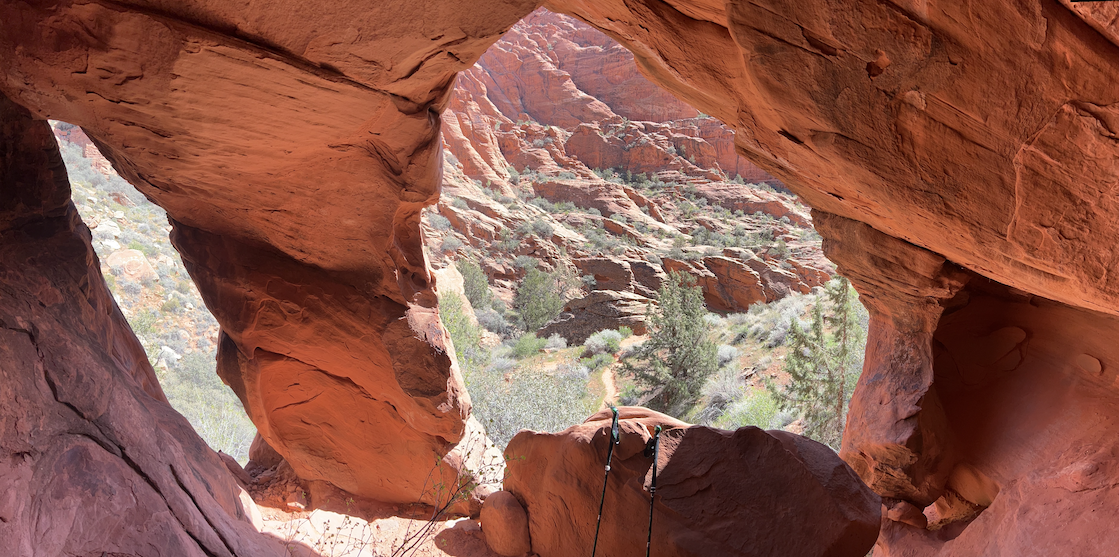
Cave Entrance
The cave was big enough to fit four people comfortably. In the back, we could see an opening in the ceiling that went up to daylight.

Cave Ceiling
Water had eroded the sandstone to make our lunch spot. I stepped back outside to look around and was spotted by a group of hikers at the top of the pass. They waved and I waved back. Later as we climbed, we would meet them coming down.
Later, at the top of the pass, we could look over the pass down into the valley we had hiked a few days before.
Behind us, the way we had come up, we could see the City of St. George and beyond.

Looking Back at St. George
It had been a hot climb but the view was worth the effort.
Back at camp, I was still thinking of the marjoram we had see earlier.

***