Round Valley Draw
Correction: While most of the photos in this post are from Round Valley Draw, some of the examples of rock formation are from nearby Willis Creek.
Campsite 14, April 30 - I have wanted to hike in a slot canyon for as long as I have known they existed. A slot canyon is a long narrow channel that has a depth to width ratio of 10:1 or greater over most of its length. A great place to hike one is in southern Utah where there are hundreds of these canyons. Escalante National Monument, where we are, is known for them!
The canyon for this hike is Round Valley Draw. You can enter from either end. We chose the west end as it is closer to where the slot starts but it is a harder entry point.
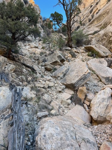
We park the Jeep at the trail head, don our packs, and head down the trail. After only a few feet we start climbing down a steep wash.
The Way We Climbed Down
The trail here is on loose gravel with boulders and stumps to scramble over. To make this section more challenging, some route finding is required. While it is officially a trail, shifting rock and erosion, due to both hikers and water, wears away the trail. We scramble and slide down the wash knowing we will have to climb back up this slope at the end of our hike.
As soon as we reach the floor of the canyon we turn east and enter the slot. The walls of the canyon are layers of sandstone.
Each of these layers was formed by a different event that deposited a layer of sand. Sometimes the sand changes color from red to white. Occasionally rocks are mixed in the sand. Layer after layer was deposited, each layer adding to the pressure on the layers below compressing the material until sand became stone. Occasionally the stone cracked.
Sometimes the cracks filled with new material and rock would form again. When the hardness of the materials didn’t match, one would wear away faster than the other.
This leaves interesting shapes protruding from the canyon walls.
Here, layers of sandstone are no longer parallel, leaving a giant crescendo made of stone.
Water fell on the stone and flowed along the surface carrying sand and gravel with it. Slowly the rock wore down making a groove that could carry more water, rock, and sand.
Grooves Carved by Flowing Water
Occasionally one of the rocks would get wedged in the channel.
The water, needing to pass, would flow around the rock carving graceful curves into the channel until the rock was no longer wedged.
Sometimes a rock in the sandstone wall became exposed. If the rock was of softer material, the rock would wear away faster leaving a hole in the channel wall.
During floods, other rocks, carried by water, bash and tumble down the channel. Occasionally one would become lodged in the little hole left by the small rock. Trapped in the hole, the new rock would churn and grind, enlarging the hole as its own surface wore away.
Rocks Wear Holes in the Canyon Walls
Time and water pass until the channel floor is 400 feet below the open land above. This is where we find ourselves.
As we hike, we realize the sand in the wash was once part of the wall. Before that, it was sand.
Rocks from upstream have colors that do not match the sandstone walls. These litter the canyon floor like confetti.
Multi Colored Rocks
A shadow above us distracts us and we look up to see a swallow diving to catch an insect. Then disappear out of view. The swallow is not in the canyon but high above it, out in the open sky.
Eventually, we come to an opening. Here the canyon walls give way to sunlight and trees. We notice a ponderosa pine that is approaching 5 feet in diameter. It is older than the trees on the surface. Here at the bottom of the canyon, loggers and fire have not been able reached it.
I Have Both Arms Full Extended!
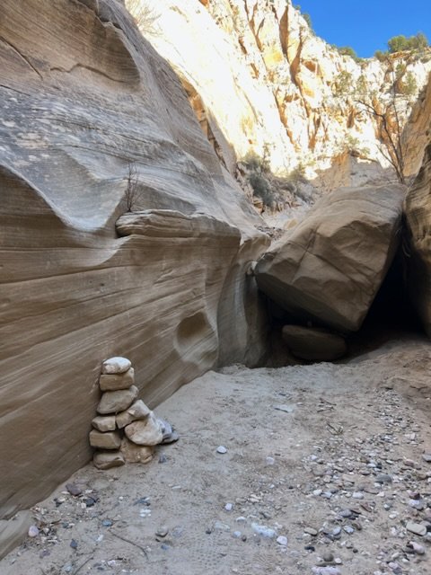
After admiring the tree’s girth, we move on to the next section of slot. We see a large boulder ahead of us with a stack of smaller rocks to one side. This is not a cairn that would normally mark the trail. This is a step.
Which way should we go?
Arriving at the boulder, we evaluate our options: over the boulder—it’s lowest top surface is 7 feet above the sandy channel; up the stacked rock step—there is a narrow sandy ledge with no handholds; return up the canyon looking for a way onto the ledge above and to the right of the boulder—there is a lot of brush and debris to scramble over with no guarantee we can get down on the other side. We consult the map and our watch. Falling or twisting an ankle here could require rescue. What interesting sight, on the other side, might we miss? While continuing on is very appealing, we decide to take the safe option and head back up the trail. There is still a lot to see on the return hike and then there is that steep climb up to the Jeep!
Update: I got the posts out of order. Click HERE for the next bit of the adventure.
***


