The Salt Post

Nov 8, While out for a drive on the Uncompahgre Plateau, I stepped out of the jeep to take a picture of a canyon and almost stepped on this little guy. I had not seen this before so, obviously, a took a photo for later identification.

Halogeton glomeratus, Saltlover
It is Halogeton glomeratus. Common name, saltlover. It accumulates salt as a defense and is poisonous to most herbivores. Apparently it is a big problem for sheep and cattle. And, as you might expect, it’s invasive. I guess I should have stepped on it after all.
It is an annual native to Eurasia that likes to grow in cold, semiarid regions. Thanks USDA for that info. That describes the area west of Delta, CO where the photo was taken.

Closeup of Halogeton glomeratus
Being called “saltlover” reminded me of a photo I took earlier in the day.

Salt Accumulation, Delta, CO
I had noticed white patches in low lying areas along the highway. I mainly noticed it in irrigated fields, but also in random low spots. I reasoned it was salt, washed from one area of the field to the low spot and left it at that. But that invasive plant made me look into if further.
The USGS says that, precipitation infiltrates the soil, where the rainwater interacts with rocks to dissolve salt. The salt then flows with the water to enter the groundwater and from there it enters streams. When the water in streams gets diverted to fields for irrigation, the salt is deposited in the soil where it accumulates as the water evaporates. This is further complicated by evaporation in reservoirs, which increases the salt concentration in any water leaving the reservoir.
In coastal areas, saltwater intrusion has a similar effect as the water rises to the soil surface where the water evaporates leaving more and more salt until the land is unusable for crops or cattle.
There are solutions such as improving irrigation to reduce the amount of water applied to soil, improving the efficiency of irrigation channels to limit concentration of salt, planting more salt tolerant crops, and capturing and treating salty water. It’s all expensive.
Where I observe salt accumulation is always along the road, because I’m driving. But winter driving in locations where there is snow and ice, usually means road crews are applying sand and salt to the road to keep them clear. That salt gets dissolved and runs into ditches beside the road or is splattered into the ditch and onto cars. Any runoff from the road ditch then adds this salt to local streams.

Snowy Road near Columbine Pass, CO - November 8, 2022
When we set out for an afternoon drive on the Uncomprahgre Plateau, I had no idea I would be blogging about salt or that I had even taken three photos related to salt. I was expecting to talk about creeks flowing northeast. I didn’t even realize I would talk about salt when I sat down with a bag of salty pretzels to start typing this. Odd how things work.
Here are the canyon photos I thought I would be talking about.

Grand Mesa, distant left (about 16 miles away) to Roubideau Creek Drainage, right
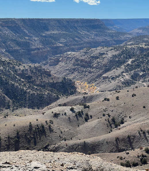
Roubideau Creek Drainage

Cottonwood Creek Drainage
As I mentioned above, the water in all these drainage areas flows northeast into the Gunnison River. The River flows north to Grand Junction where it meets the Colorado River. From there it still flows north, following approximately the same route as I-70 into Utah. Once in Utah, the river finally starts flowing south, toward Lake Powell.