Elementary School Geography
When you move from state to state as we have, if you are paying any attention at all you start to notice small cultural differences. Usually it’s linguistic or legal, but here we have noticed differences that are geography-based.
When you travel in Colorado, or probably any mountainous area, when you enter a new municipality, there is a sign outside of town that says the name of the place but instead of saying the population, as we are used to, they give the elevation.

Snowplow Target Outside Steamboat Springs
I think it is much more practical as the population will change with every census requiring the sign to be replaced. If the elevation of a place changes enough that its sign needs to be replace, then a good portion of the actual town probably needs to be replaced too. Everyone here seems to know the elevation of their house. Here we live at 7,600 but in Montrose we lived at 5,800. In Connecticut we lived at 450. In Kansas we lived at 1,000. Yeah, I didn’t have to look up any of those elevations because I looked it up when I lived in those places. Does this mean I have found my people?
Knowing what elevation someone lives at also gives you a bit of insight to the person. It gives you a good idea if they live in town or up in the mountains.
We have met many people in the area. Few are originally from Colorado. Even those that are from the state are rarely still living in the town they grew up in. If they moved here from anywhere within Colorado and you ask them where they moved from, they will say something like Front Range. That’s when I nod and act like you know exactly what they are talking about. I guess I better learn a few mountain ranges. And there are a few!
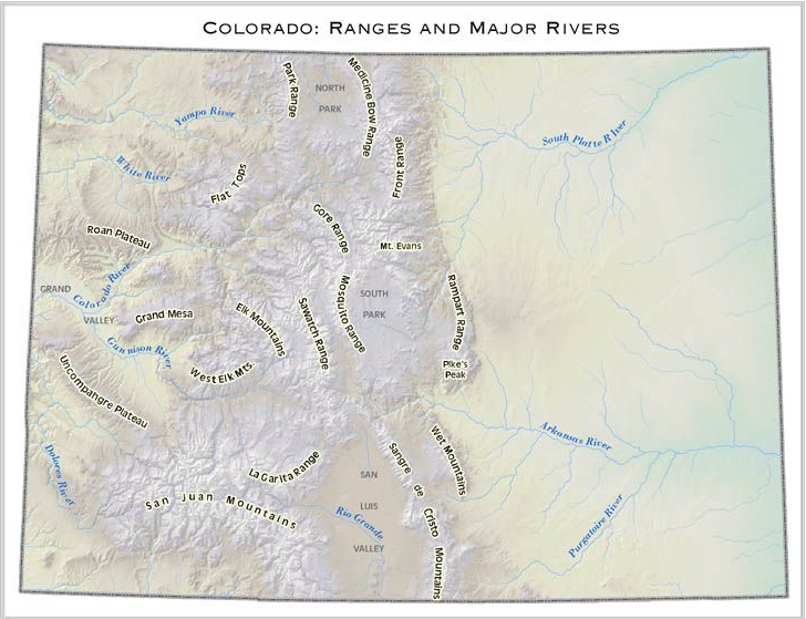
Some of the ranges are large or well known, others are small and isolated. The better known are: the Front Range - west of Fort Collins to Denver); The San Juans - south West CO; or the Sawatch Range – Leadville to Buena Vista. There are several advantages to telling people the mountain range you’re from. If it is a really small town, the people you’re talking to might not have heard of it, but if they know a bit about the state, they may know the range. It’s also a clever way to answer the question without specifically saying where you’re from. I think of it in the same way that I think of the question, “What do you do for a living?” Some people take this to mean, how much money do you make. Other people take the question as in inquiry into interests you might have in common. If you’re from the Front Range you probably live and work in the Denver area. If you are from the Sawatch Range, think touristy but with a stable population of full timers. If you’re from the San Juans there is a good chance you live in a small isolated town that started as a mining camp.
So where am I from? I used to live in the San Juans, but I recently moved to the Park Range. The Park Range means Steamboat Springs, a ski community, or a ranch area, take your pick.
Other mountain ranges we have visited include the Sangre De Cristo Mountains. The name means blood of Christ in Spanish. This range is in the south-central part of the state and extends into New Mexico. We traveled through this area on our way to Arkansas. It is a rural part of the state with ranching the major occupation in the San Luis Valley to the west of the mountain range. To the east, are the Wet Mountains. We haven’t been there yet but they run from Canon City to Colorado City. This range forms the boundary between the plains and the mountains.
North of the Wet Mountains is the Rampart Range. This is north of Pike’s Peak and west of Colorado Springs. We almost move to Colorado Springs instead of Montrose, but these was a large military base across the highway from the house, so we ultimately decided on Montrose. To the west of the Rampart Range is a large valley, called South Park. At the northern edge of the valley is the town of Fairplay that is the visual basis for the TV show, South Park. Looking farther west are the Mosquito and the Sawatch Ranges which are separated by a narrow valley running north to south that is home to Buena Vista and Salida. And even farther west is the town of Crested Butte sandwiched between Sawatch Range and the Elk Mountains. Still farther west is the West Elk Mountains, home to the Black Canyon of the Gunnison and Montrose. From the West Elks to the Utah border is the Uncompahgre Plateau that is a slow isolated climb riddled with deep canyons all the way to the Dolores River along the state border.
North and west of the West Elks is Grand Mesa and the Grand Valley which I have discussed previously. Moving to the North is the Roan Plateau with the Little Book Cliffs.

Roan Plateau in the Distance with Colorado National Monument in the Foreground
The cliffs are supposed to look like books on a shelf. I don’t see the books but if you happen to be driving on I-70 you can decide for yourself. Halfway between the Roan Plateau and the Park Range, where we live now, are the Flat Tops. The Flat Tops are in fact flat on top. This is the result of lava flowing over an uplifted basin. The land around the lava flows was carved out by glaciers leaving the Flat Tops. I guess that lava flow accounts for the use of crushed lava on icy road here rather than sand or salt. I digress.

A view of a portion of the Flat Tops

View of the Flat Tops from Mt. Werner
We can forget the eastern half of the state. No mountains there, just plains. Did I miss some areas? Absolutely. I got my map of mountain ranges from an elementary* school! But I’m learning and that’s the level I’m at. In my defense, it’s a big state with rugged terrain and interesting geology. Now if I meet someone and they tell me what range they are from I won’t feel so uninformed when I say, “Sorry I’m not familiar with that area. What larger range is it near?”
*Thanks to Shelledy Elementary Fruita, Colorado for use of their map of mountain ranges of Colorado.